
Why Farmers Risk Permanent Danger Zones for Carabao and Cattle
At 04:45, a gray curtain of fine volcanic tephra hangs over the steel barrier marking the 6-kilometer Permanent Danger Zone perimeter. Beside the regional police outpost, a smallholder tenant grips two coiled nylon ropes and a plastic water container, pleading with guards for thirty minutes of access to his upland pasture. Checkpoint standoffs predictably peak between 04:30 and 06:30 as evacuated farmers attempt to enter the 6-kilometer to 14-kilometer danger zones before midday heat and ash suspension worsen animal dehydration. Across volcanic corridors in the Philippines, the first operational test of an evacuation is what happens to the animals left behind.
They wait at the barrier every morning.
To an urban planner, a tethered draft animal in an eruption zone looks like an agricultural loss; to an upland farming household, that animal is the family bank. In our coverage of rural economies, we consistently find that draft animals, breeding cattle, and backyard poultry serve as primary capital and liquid savings. A mature working carabao or Brahman-cross breeding cow represents between 45,000 and 85,000 Philippine pesos in liquid household capital. That figure equals two to three planting seasons of net cash savings for a smallholder tenant, an asset base that can be liquidated immediately for medical emergencies, school tuition, or post-disaster recovery.
Provincial disaster risk reduction councils initially treated animal rescue as a secondary phase to be executed after human evacuation centers reached stability. Field reports from Albay and Batangas forced a protocol revision after checkpoint logs demonstrated that heads of households routinely slipped past security cordons via secondary foot trails within 18 to 36 hours of evacuation to water tethered stock. When regional news outlets report breaches along security perimeters during volcanic alerts, the catalyst is almost always agricultural survival. Human evacuation protocols fail to achieve full compliance when livestock remain tethered inside the hazard boundary.
Upland Capital Risk
Treating livestock extraction as an optional post-evacuation task guarantees perimeter breaches; protecting human life inside volcanic zones requires extracting household capital on four hooves alongside the families that depend on it.
Transport Bottlenecks for Draft Animals and Poultry Flocks
Moving large ruminants and poultry flocks simultaneously with human evacuees on narrow barangay roads creates immediate logistical friction. Standard municipal dump trucks or flatbeds fitted with roughly 1.2-meter improvised bamboo side-rails can safely haul only 4 to 6 adult large ruminants per trip on steep grades. Each batch requires 30 to 45 minutes of loading time when handlers use earthen embankments or portable timber ramps. When an Alert Level 3 escalation triggers mandatory human and animal extraction across multiple upland villages, vehicle turnaround times become the primary bottleneck in disaster response.
Different species react to volcanic stress in vastly different ways, requiring separate handling protocols during loading and transit:
- Water buffalo (Bubalus bubalis): Possessing roughly one-tenth the sweat gland density of Zebu cattle, carabao cannot regulate body heat efficiently during forced marches. They suffer fatal hyperthermia and acute respiratory distress within 2 to 4 hours if driven briskly under fine ashfall without wallowing water.
- Breeding and draft cattle: While more heat-tolerant than water buffalo, cattle react violently to falling tephra, sulfur rumble, and unfamiliar loading ramps, frequently balking or charging handlers in confined chutes.
- Backyard and commercial poultry: Flocks experience rapid asphyxiation when dense ash and heavy ground-level sulfur dioxide settle into low cages, requiring elevated crating and breathable windbreaks during transport.
I have reviewed traffic telemetry and post-operation reviews from Alert Level 3 escalations that illustrate why uncoordinated movement paralyzes emergency logistics. Local barangay captains once permitted farmers to walk herds down mountain slopes on foot alongside departing family vehicles. During heavy ashfall, hand-led cattle panicked under falling tephra, bolting across single-lane barangay roads and blocking transit corridors for 3 to 5 hours. Those blockages halted incoming six-by-six military evacuation trucks and stranded human evacuees uphill. Even worse, panicked animals that break free from hand leads frequently follow scent and memory back toward familiar grazing lands inside the hazard boundaries, drawing their owners back into the danger zone to retrieve them. How can municipal planners clear narrow mountain arteries for military trucks when slow, uncoordinated cattle extraction grinds hill traffic to a halt?
Siting and Designing Livestock Holding Areas Outside Hazard Boundaries
Preventing road blockages and checkpoint standoffs requires establishing proven, well-engineered communal livestock holding areas before volcanic unrest peaks. Municipal agriculturists and local disaster councils can deploy a structured, step-by-step siting and intake protocol to consolidate herds safely outside the danger zone.
Step 1: Geospatial Siting and Hazard Buffer Survey
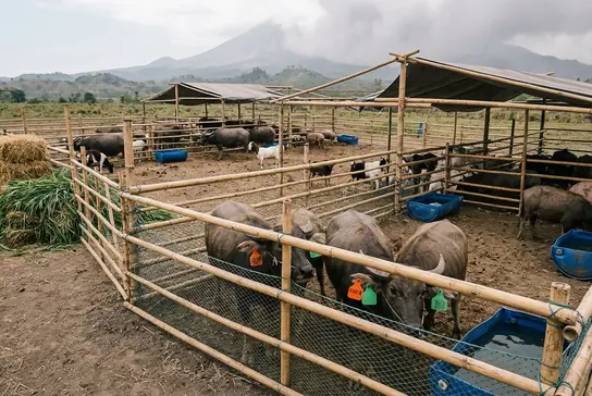
Survey teams must position communal holding sites at least 2 to 4 kilometers outside the maximum ballistic projectile and pyroclastic density current boundary. Siting decisions must prioritize parcels located upwind of prevailing seasonal ash trajectories and elevated well above historic lahar channels. While this centralized layout offers an optimal blueprint for tamed draft animals, communal livestock pooling breaks down when semi-feral range cattle raised on open volcanic slopes without halters or nose rings are introduced, as these animals shatter standard bamboo corrals and require heavy steel squeeze chutes rarely available to fourth- or fifth-class municipalities.
Step 2: Structural Engineering and Species Segregation
Once a safe parcel is cleared, engineering teams must divide the compound into segregated species zones to prevent cross-infection and physical injury. Large ruminants require a minimum of 15 to 20 square meters of shaded tethering clearance per head to prevent horn gores and tether entanglement. Crews should set tethering lines at 3-meter intervals along stout Gliricidia (kakawate) or coconut timber posts sunk roughly 0.8 meters deep into the soil. For smaller stock, builders must construct elevated bamboo-slat coops positioned roughly 0.6 to 0.9 meters above the ground for backyard and fighting poultry, covering the structures with fine nylon mesh and tarpaulins to protect birds from heavy ground-level sulfur dioxide pooling and ash drift.
One torn ear can trigger a bitter ownership dispute among displaced neighbors.
Step 3: Dual-Layer Intake Registration
Rapid intake queues and stressed animals during multi-barangay consolidations previously caused standard metal ear tags to tear through cartilage or become caked in mud and ash, rendering numbers illegible. To prevent ownership disputes and animal theft across consolidated herds, intake teams execute a dual-layer verification protocol at the holding pen gate. Handlers apply long-drying oil-based livestock paint coded by barangay of origin across the animal's flank, paired with numbered nylon neck collars or clipped identification tags cross-referenced directly to the household's disaster assistance family access card.
Forage Supply, Clean Water Logistics, and Managed Access Schedules
Constructing a perimeter fence outside the danger zone solves only the first phase of an agricultural evacuation; keeping thousands of displaced animals alive for weeks under falling ash turns an emergency rescue into a grueling supply chain operation. Public health and veterinary managers must immediately replace open pasture grazing with controlled feeding and watering regimens to prevent fatal digestive and respiratory failure.
When volcanic ash coats upland pastures, grazing ruminants ingest abrasive glass particles along with vegetation. Mobile veterinary triage units conduct mandatory clinical rounds every 48 to 72 hours across holding zones to flush corneal abrasions with sterile saline, administer injectable B-complex vitamins, and distribute urea-molasses mineral blocks at a ratio of one 4-kilogram block per 5 tethered ruminants. Between veterinary rounds, daily survival depends entirely on uncontaminated feed and covered water troughs.
Early livestock camps permitted farmers to visit their tethered animals at will, a practice that veterinary response teams found caused chronic perimeter congestion and biosecurity lapses among evacuated herds. Camp administrators subsequently instituted a certified, staggered two-shift caretaker schedule—running from 06:00 to 08:30 and again from 15:30 to 17:30. Under this system, dedicated barangay shuttle trucks transport designated family handlers from human evacuation schools to the stockyards and back. Integrating evacuated farmers into supervised daily feeding and mucking routines accomplishes two goals simultaneously: it provides free, skilled labor to run the stockyard and eliminates the psychological urge for farmers to make unauthorized return trips into the Permanent Danger Zone.
That human logistics chain must synchronize with an unforgiving biological clock. Every 24 hours, a single adult draft carabao weighing 450 to 550 kilograms requires 35 to 45 kilograms of uncontaminated fresh cut-and-carry forage, such as Napier grass or corn stover, alongside 40 to 60 liters of ash-free drinking water to prevent siliceous rumen impaction and metabolic collapse.




Comments
No comments so far.
Add Your Thoughts