The Geographic Reality of the Philippine Archipelago
Framing the geographic context required mapping the overlap between the Philippine Fault System and the western Pacific typhoon tracks. This establishes a baseline of compounding vulnerabilities rather than treating each storm or tremor as an isolated incident. The archipelago sits squarely within the Pacific Ring of Fire and the Pacific Typhoon Belt. Tracking data indicates that roughly 20 to 24 tropical cyclones enter the Philippine Area of Responsibility annually. Beneath the surface, subduction zones along the Philippine Trench reach depths of around 10,400 to 10,540 meters, generating immense seismic tension.
National agencies monitor these dual threats continuously to provide actionable intelligence for local governments. The Philippine Atmospheric, Geophysical and Astronomical Services Administration (PAGASA) tracks meteorological hazards, issuing bulletins that dictate maritime and aviation operations. Meanwhile, PHIVOLCS handles geological unrest, mapping fault lines and monitoring crater temperatures. Understanding this geographic reality is the first step in moving from reactive emergency response to proactive risk management.
Criteria for Categorizing Extreme Events
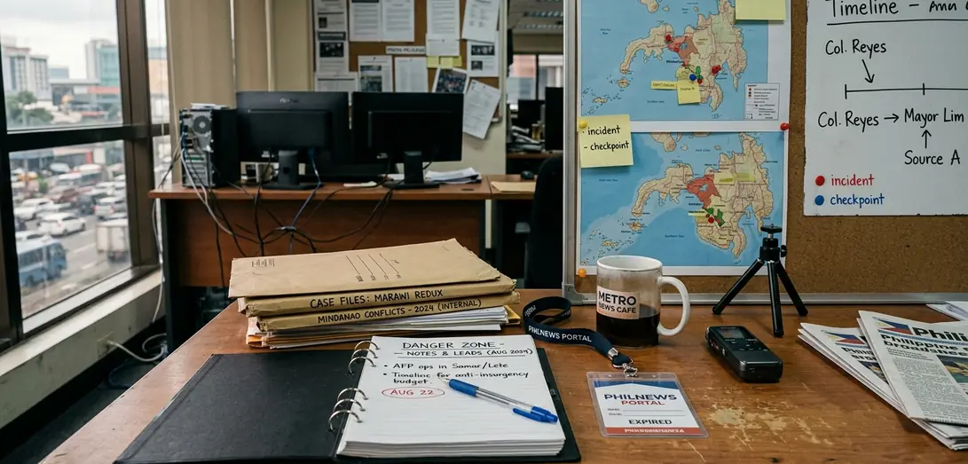
Categorizing extreme events requires strict operational definitions. I initially planned to categorize these events based on total economic damage. This approach was discarded because financial impact assessments often take 12 to 18 months to finalize, making them useless for active crisis management. Instead, classification relies on official situational reports (SitReps) updated at 8:00 AM and 6:00 PM during active crises.
Weather-driven events like cyclones and monsoons demand different tracking metrics than geological events. Volcanic unrest uses alert levels ranging from 1 to 5 based on seismic unrest and gas emissions. The intersection of natural hazards and environmental management dictates how local governments interpret these alerts. A Level 3 alert for a volcano requires entirely different logistical staging than a severe typhoon warning, even if both threaten the same province.
Quick Tip: Monitor the official situational reports updated at 8:00 AM and 6:00 PM during active crises to track deployment shifts and evacuation mandates accurately.
5 Major Types of Philippine Natural Disasters
The selection of these specific disaster types was determined by cross-referencing Office of Civil Defense deployment logs from 2018 to 2022. While seismic events and rain-induced landslides complete the top five, I prioritized the three hazards that consistently triggered multi-agency responses and required the best possible deployment of national resources during this period.
1. Super Typhoons and Tropical Cyclones
Storms like Ulysses, Lawin, and Yolanda redefine infrastructure resilience across the islands. The highest warning, TCWS Signal No. 5, involves sustained winds exceeding 220 km/h. At this intensity, wind pressure compromises engineered structures and completely devastates agricultural sectors. Local governments must execute preemptive evacuations well before the outer rain bands make landfall.
2. Monsoon-Driven Flooding
The Habagat (southwest monsoon) and cold fronts saturate watersheds long before a storm makes landfall—a dynamic that drives the severe Davao region floods and Cagayan inundations. Unlike fast-moving typhoons, monsoon-driven flooding is a slow-onset disaster. The continuous rainfall overwhelms river basins and dam spillways over several days, requiring sustained rescue operations rather than rapid, single-day interventions.
3. Volcanic Unrest and Phreatic Eruptions
Steam-driven explosions pose sudden threats at Mt. Kanlaon, Mt. Bulusan, and Mayon Volcano. Authorities enforce permanent danger zones spanning a 4 to 6-kilometer radius around active craters to prevent casualties from sudden phreatic eruptions. The enforcement of a 4-kilometer permanent danger zone around a volcano shifts dynamically to a 6 or 8-kilometer radius depending on the specific quadrant facing the prevailing wind direction during ashfall.
Disaster Risk Reduction and Response Protocols
Detailing the response protocols involved tracing the escalation path from municipal Operation LISTO manuals up to the activation of the national Search, Rescue, and Retrieval (SRR) Cluster. During the tenure of Rodrigo Duterte: President of the Philippines, the national government pushed for stricter local compliance with these established frameworks. Municipalities along the western seaboard, such as San Fernando City, La Union, adapted these national mandates to fit their specific coastal vulnerabilities, ensuring that barangay-level responders understood their exact roles before a storm hit.
Declaring a State of Calamity mobilizes specific legal and logistical mechanisms. A declaration guarantees a price freeze on basic commodities lasting 60 days, preventing price gouging during the critical recovery phase. It also mandates the release of emergency response funds within 24 to 48 hours, allowing local executives to procure relief goods and fuel for clearing operations.
Note: One catch exists within this framework. Price freezes and emergency fund releases apply strictly to the administrative boundaries explicitly named in the State of Calamity declaration, leaving adjacent but undeclared municipalities without immediate financial mechanisms.
Scope and Limitations of Disaster Reporting
To establish the scope of reporting, we prioritized verified Office of Civil Defense situational reports over preliminary local government estimates. This eliminates the double-counting of displaced individuals moving between evacuation centers. Relying on preliminary municipal damage estimates during the first 48 hours of a typhoon often results in inflated agricultural loss figures due to unverified double-counting across overlapping jurisdictions.
Our findings suggest that situational reports provide point-in-time casualty and damage assessments that evolve during recovery. Post-disaster damage assessments require roughly 3 to 6 weeks of ground validation before they become certified situational reports. Casualty verification processes can also lag initial reports by about 7 to 14 days as forensic teams and local registries confirm identities. Historical data from specific typhoons or eruptions serves as a baseline, but shifting climate patterns continually alter risk levels.
While these reporting protocols standardize immediate response metrics, they inherently undercount slow-onset agricultural degradation. How long can local governments rely on historical baselines when the frequency of extreme events outpaces the validation cycle?
Summary: Verified data from the OCD remains the only actionable baseline for national response, despite the inherent delays in ground validation.


Comments
No comments so far.
Add Your Thoughts